Admit it, once Google Earth was rolled out, you absolutely took a disproportionate amount of time checking out all the localities and areas on it to see if you can find something nostalgic, cool, or flat-out bizarre. And then Google Street View appeared and it was a game changer. Needless to say, you like maps. We’re all nerds like that.
And, well, there’s more to maps than just that. Check out these interesting takes on the US as seen from a top-down perspective, but instead of seeing vast landscapes and the occasional architectural screw-up, you see fun facts and information that might just make you smarter. I mean, it will if it’s not something you already know.
Listen beautiful relax classics on our Youtube channel.
Scroll on.
#1 Tree Cover Map Of The US
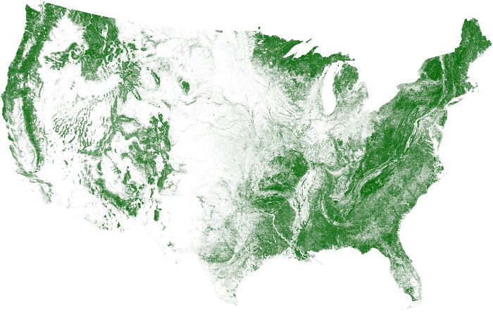
Image credits: DrWendigo
#2 More People Live Inside The Red Area Than The Grey Area
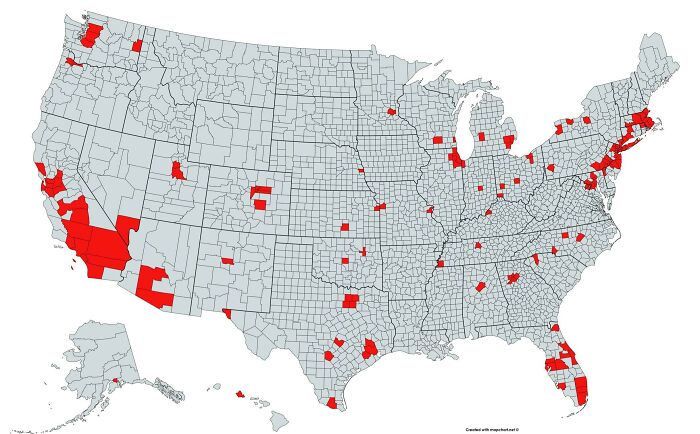
Image credits: lex52485
#3 Light Pollution In The United States
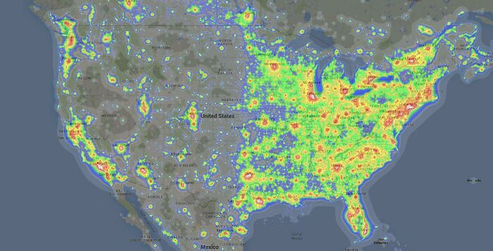
Image credits: there_is_no_try
It goes without saying that the United States is a pretty big country. And, as such, there’s ample opportunity to spot differences and variation on a slew of variables across the entire map.
Like, you probably never really needed to know how thick light pollution is across the US, but, hey, now you know that it’s the eastern part that’s very intense, and the western part is more or less not as polluted.
#4 Map Showing The Loudest And Quietest Areas In The US
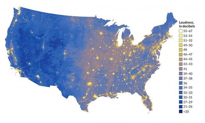
Image credits: Knight1114
#5 Topography Of USA
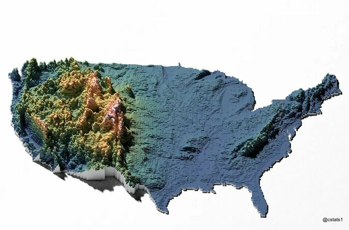
Image credits: TotherCanvas249
#6 US States By Violent Crime Rate
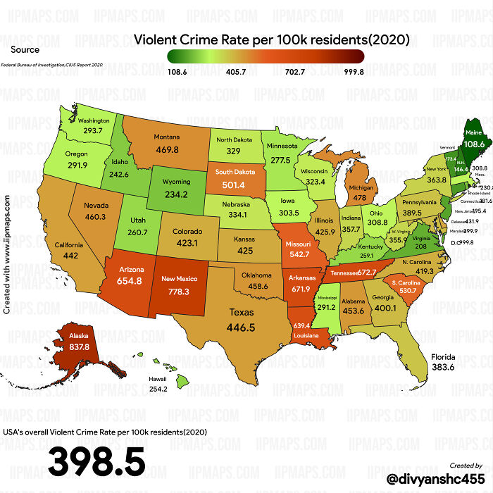
Image credits: Specific_Ad_685
And there is definitely a small contingent of people who benefit from this information—researchers, people who want to move states—it’s also there to make you look cool at parties with all that trivia you now know
All jokes aside, it’s useful to know where you’re going to live: what’s the crime rate there, how natural is the landscape, how populated it is—all of these factors are nice to know since you are deciding on moving there permanently.
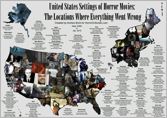
#7 Here’s A US Map Showing Where Horror Movies Took Place (By Andrew Brick)
Listen beautiful relax classics on our Youtube channel.
Image credits: dixi_annalis
#8 US States Scaled Proportionally To Population Density
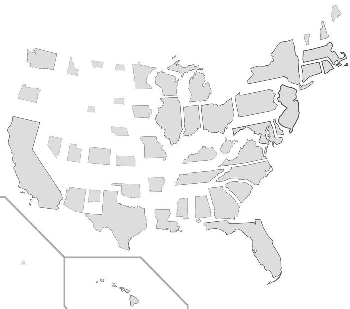
Image credits: StarboardCapsized
#9 Abandoned And Out-Of-Service Railroad Lines
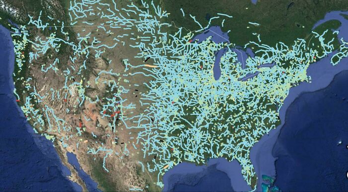
Image credits: StrangeMorris
But if that example is too specific, then maybe consider this: if you own a car, it’s likely that you use navigation on the regular. Apps like Google Maps and Waze have made it possible for people to have a bit more comfort in the car as at least you know where you’re going and why it’s taking you an extra 14 minutes to get there (darned traffic jams).
#10 States With A Smaller Population Than Los Angeles County
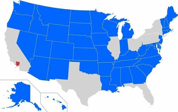
Image credits: SwiftOryx
#11 Most Oddly Named Town In Each US State
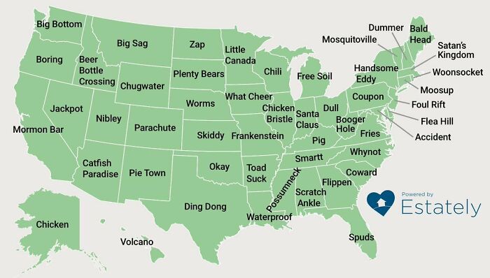
Image credits: TooHigh2Die420
#12 Map Of The United States’ 8 Million Miles Of Roads, Streets And Highways
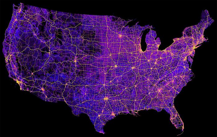
Image credits: SkyHawk2112
But seeing that arrow in your navigation is one thing. There’s an entire surrounding everywhere you go—knowing what’s around us brings us comfort and safety. And you never know when a beautiful lake will be sitting right next to where you keep passing by, but never look beyond that patch of trees that disguise it, making you think it’s just more forest there. Maybe taking a bicycle might help fix that problem. But check your map first!
#13 Red And Orange Areas Have Equal Populations
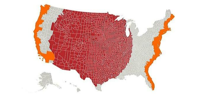
Image credits: Cogo5646
#14 The Most Efficient Route Between Every Springfield In The United States
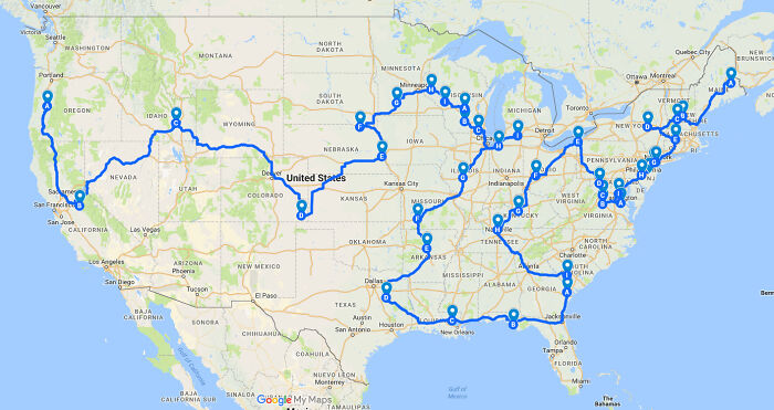
Image credits: GreenMobius
#15 Countries With Bases In The USA
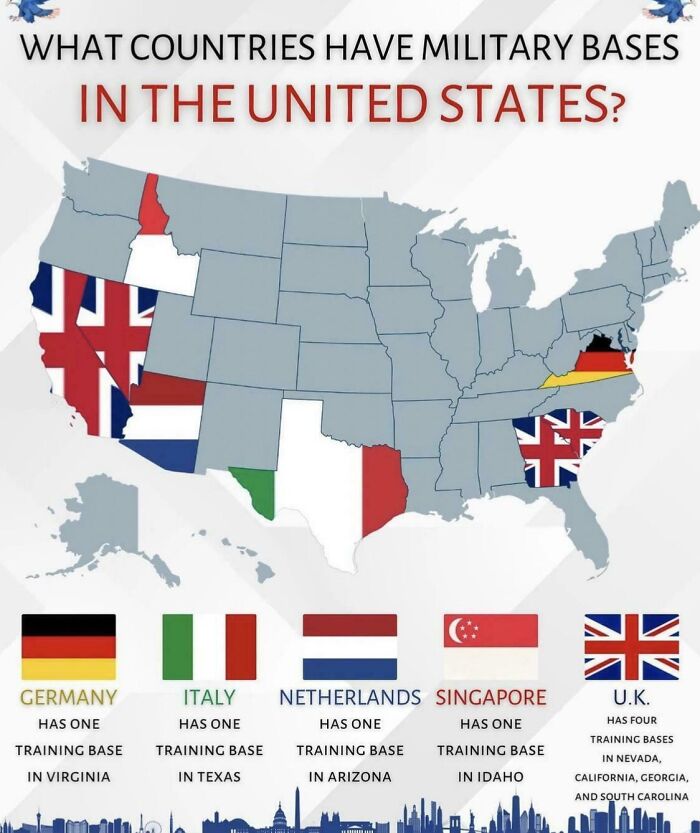
Image credits: ActiveHelicopter6644
Another argument for the importance of maps is the idea of seeing where you’re going, where you are, and where you’ve been. It doesn’t really have to be a literal geographical map at this point, but a literal one might work too—just think of Google Maps Timeline.
If you’re unaware, Google Maps Timeline is a monthly service by Google that sends you recaps of where you’ve been over the past month, showing how many countries, cities and places you’ve visited in retrospect.
#16 US State Mottos
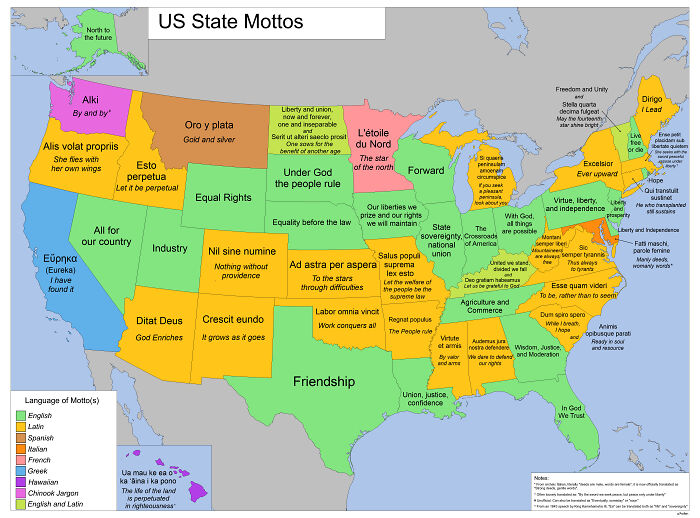
Image credits: Aofen
#17 If US Land Were Divided Like Us Wealth
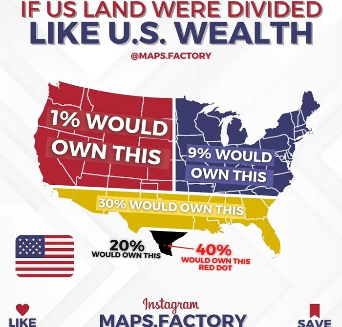
Image credits: mapsfactory
#18 US Counties With GDP Over $100b
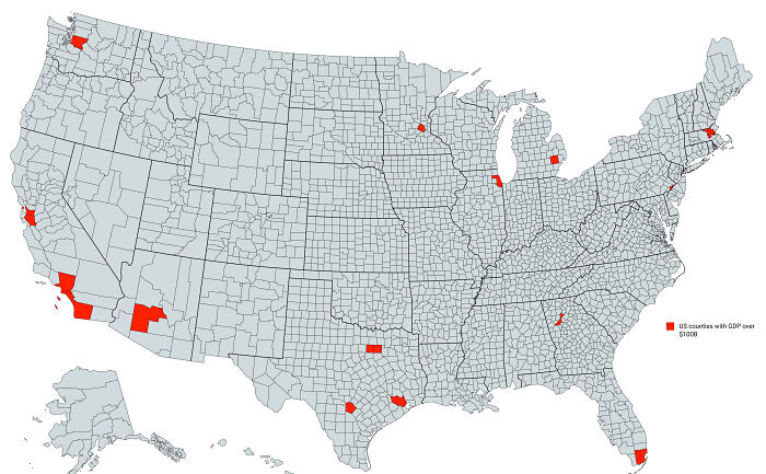
Image credits: im_sorry_wtf
Outside their practicality, maps also ground us in reality. That can be either a good or bad thing depending on a number of factors, but there’s the idea that maps remind us we all live on the same planet. Sure, there’s a great divide among nations and countries in terms of social, economic and climate factors. But we’re all in this together—we’re all citizens of this world. And that’s what folks ought to focus on.
#19 Most Spoken Languages In The US Beside English/Spanish
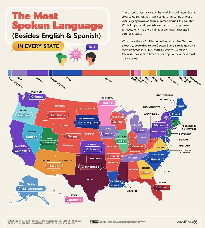
Image credits: kvnbtl
#20 The Most Dangerous Cities In The US
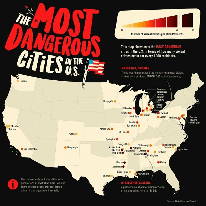
Image credits: AdAbject6946
Some might argue that maps help us stay curious. Just like a change of scenery can help us gain some perspective and learn something about ourselves and others, i.e. travel, the idea of looking at a map and plotting your next adventure might just inspire an extra bit of curiosity and make you think “hey, I’ve never heard of this place.”
#21 US States By Wikipedia Article Length
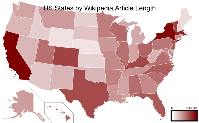
Image credits: Gullyn1
#22 Usage Of ‘Dang’ In The United States
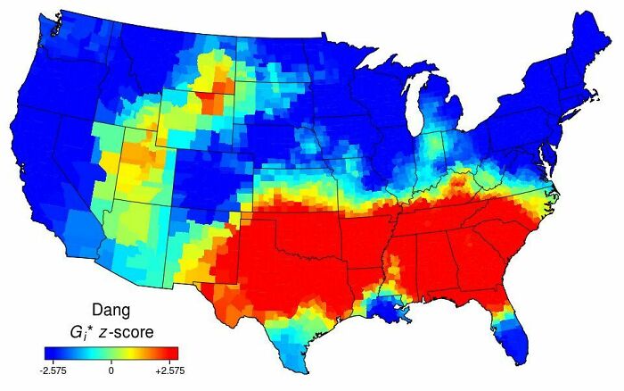
Image credits: AJgloe
#23 How America Utilizes Its Land
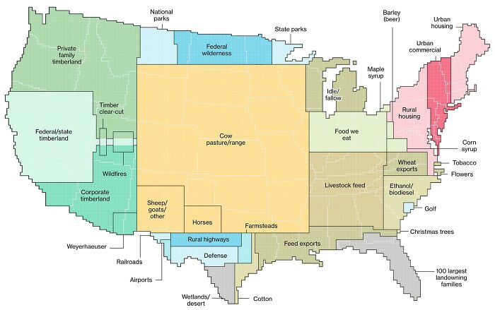
Image credits: reddit.com
#24 Purchased Territories Of The USA
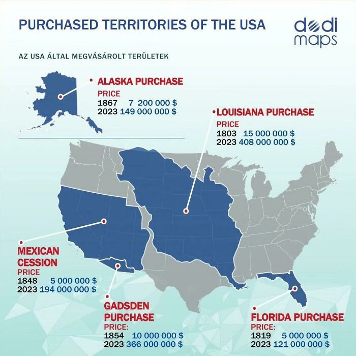
Image credits: Hockputer09
#25 Most Popular Dog By US State
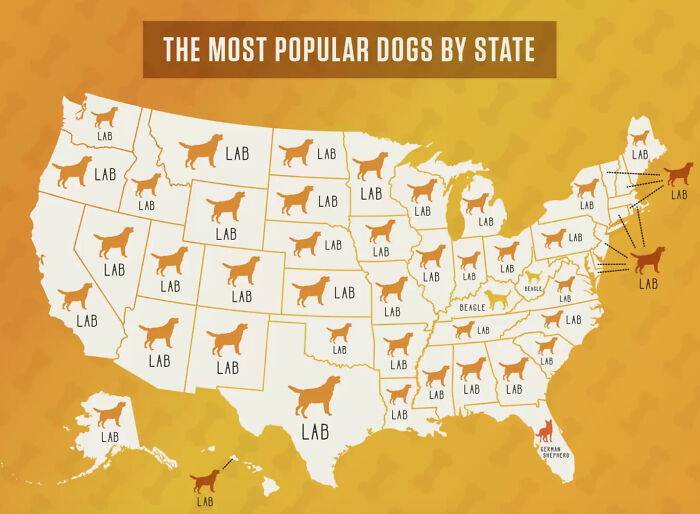
Image credits: smooshedeggbog
Lastly, maps are an integral part of how we function as human beings. There’s a geographical map (of which there are many types), a building evacuation map, a website map, a mind map, process maps, network maps, story maps, treasure maps, and, to some degree, flowcharts. Needless to say, we need all of these. Especially treasure maps.
#26 The Most Popular Unisex Baby Names By US State (2020)
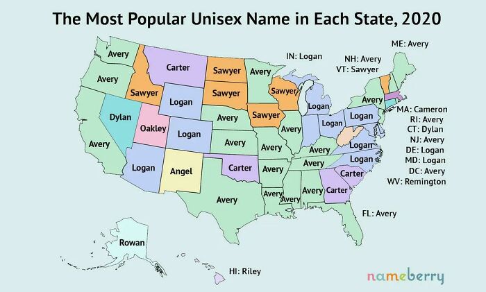
Image credits: Ganesha811
#27 United States Population Lines
Image credits: AJgloe
#28 US States By Human Development Index
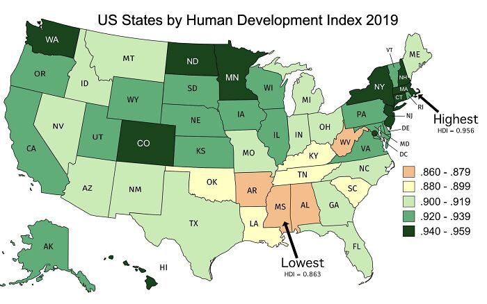
Image credits: untipoquenojuega
#29 US Pronunciation Of Pecan
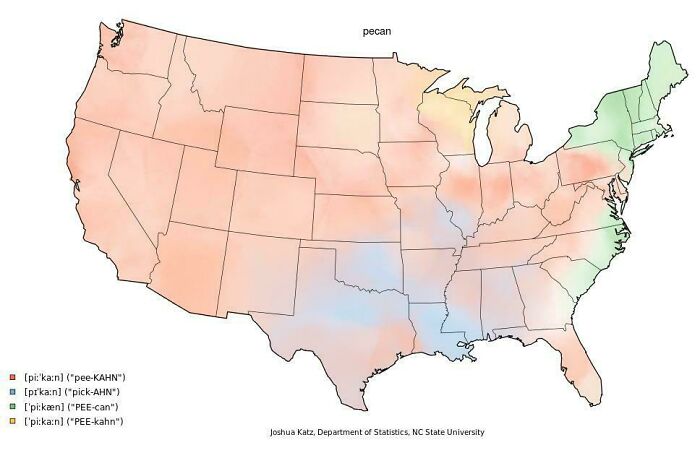
Image credits: casualiandie
#30 Illegality Of Women Going Topless In Public In The US
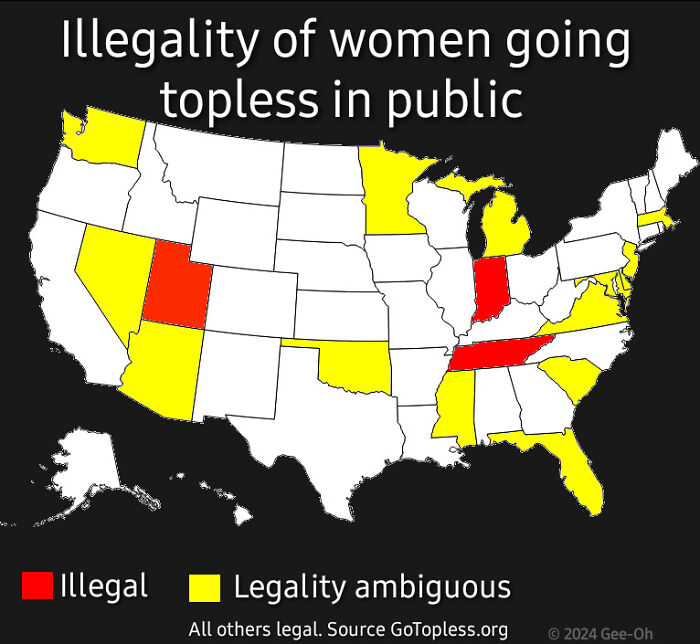
Image credits: Gee-Oh1
So, what are your thoughts on any of this? Have some maps that you were blown away by? Share them, or anything map related, really, in the comment section below!
And if you need more maps, we’ve got tons. No, that’s not an overstatement. Yep, it keeps on going. OK, that’s enough.
#31 Highway Signs For Each US State And Territory
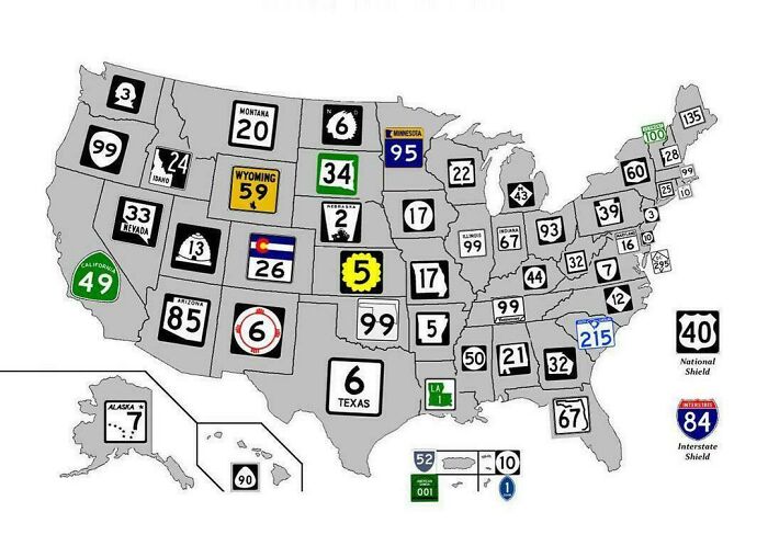
Image credits: _HorseWithNoMane_
#32 Average Color Of US State Based On Satellite Imaging
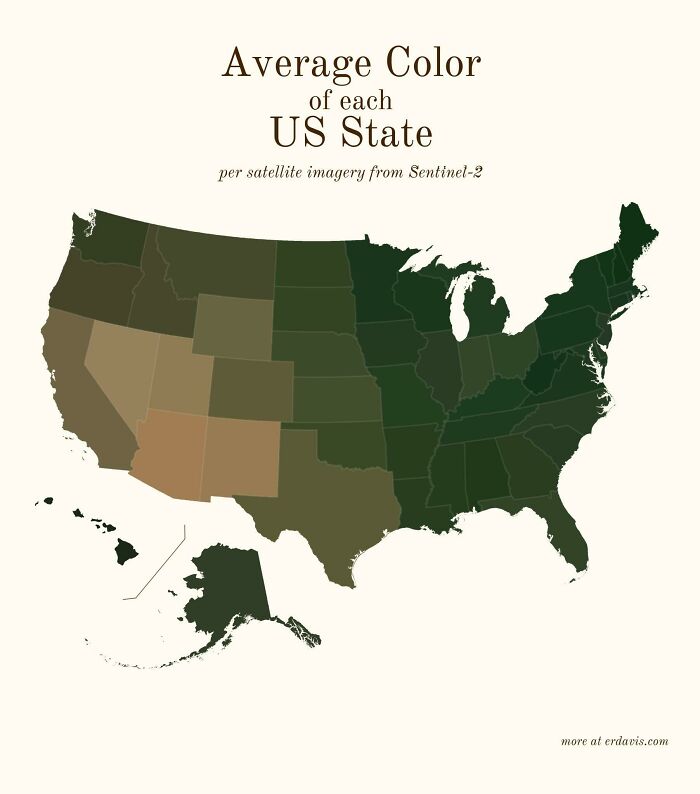
Image credits: SnooMacarons8038
#33 Origin Of US State Names
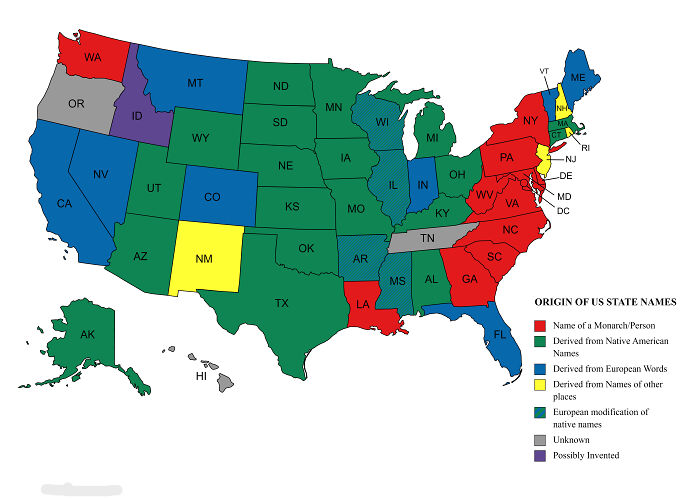
Image credits: reddit.com
#34 Most Popular US Female Baby Names 2022
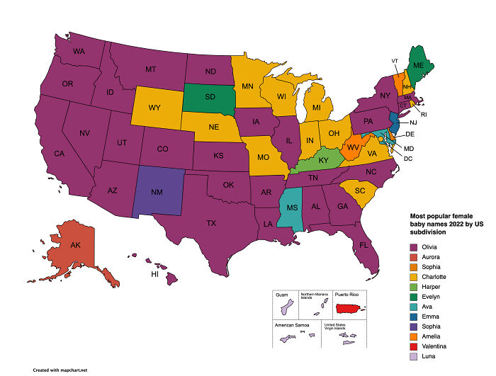
Image credits: Jakyland
#35 US Racial/Ethnic Diversity Map
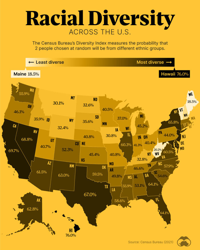
Image credits: HtxCamer
#36 Average Money Spent On Weddings In US States
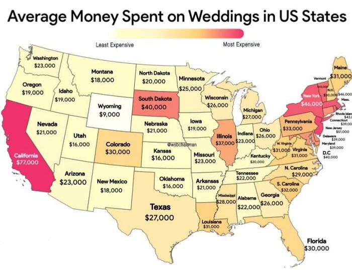
Image credits: Starry_Night0123
#37 Most Expensive Toll Roads In The US
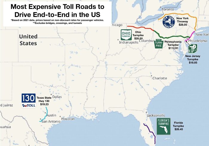
Image credits: ixvst01
#38 Seat Belt Laws In The US
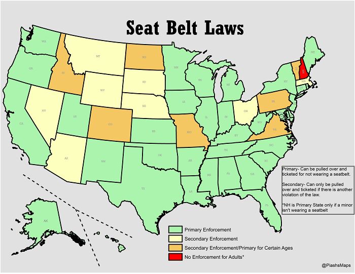
Image credits: Mangolicious786
#39 US Obesity Map
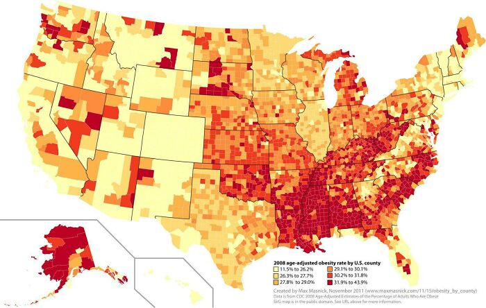
Image credits: Ok_Gear_7448
#40 US Territories
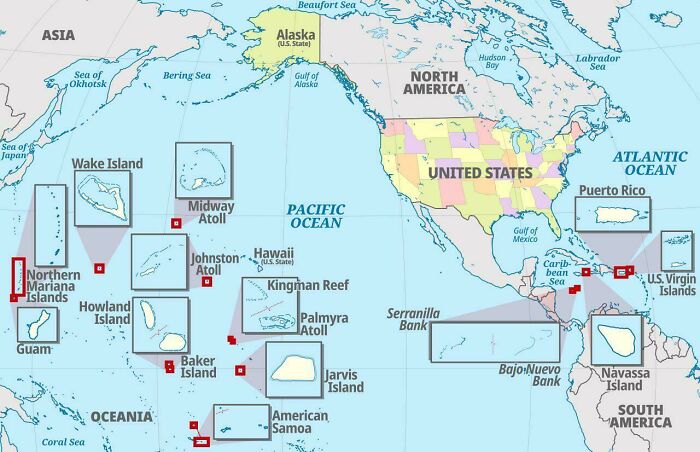
Image credits: jhseeterlin
#41 The Safest Cities In The US
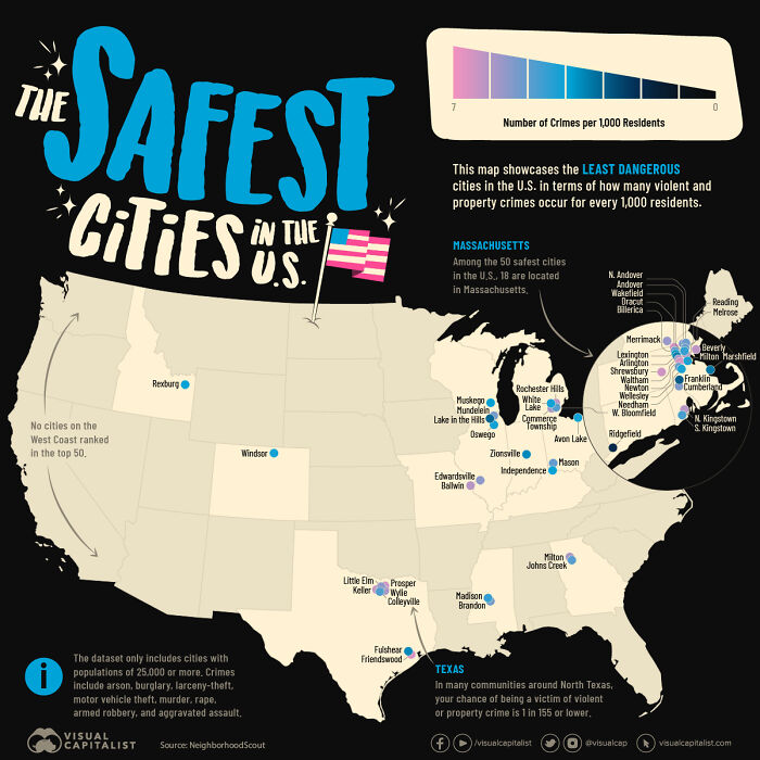
Image credits: AdAbject6946
#42 Which Coffee Shops Has The Most Locations Per State
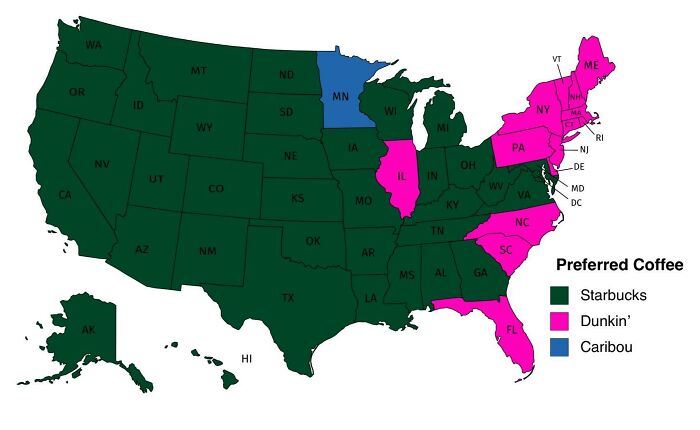
Image credits: dannywat3rm3lon
#43 Air Traffic Control Zones In The USA
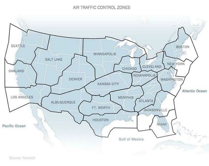
Image credits: lucyeeliza
#44 US Housing Shortage
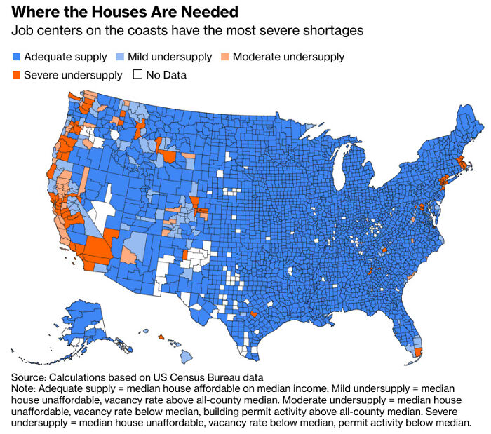
Image credits: Songs4Roland
#45 Regions Of The U.S. That Don’t Officially Celebrate Christopher Columbus Day
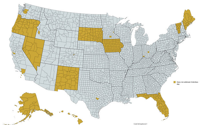
Image credits: dips9
Source: boredpanda.com