Who doesn’t love a good map? I’d even say we’d get lost without one. They enrich our understanding of the world in a simple, visual way.
Maps teach us not only about the size and shapes of countries but also show many more interesting things, like earthquake locations and wealth distribution. The local status of gay marriage or car reliance. Pretty much everything we have data on!
So let’s revisit this subreddit for a new dose of cartography — it hits just as strong as the previous ones.
#1 Lithuania Has Made A Map Of Magnets In Which Each Magnet Can Only Be Found In A Specific Area, To Boost Tourism, Specifically Local Tourism. (Credit To Demilked)
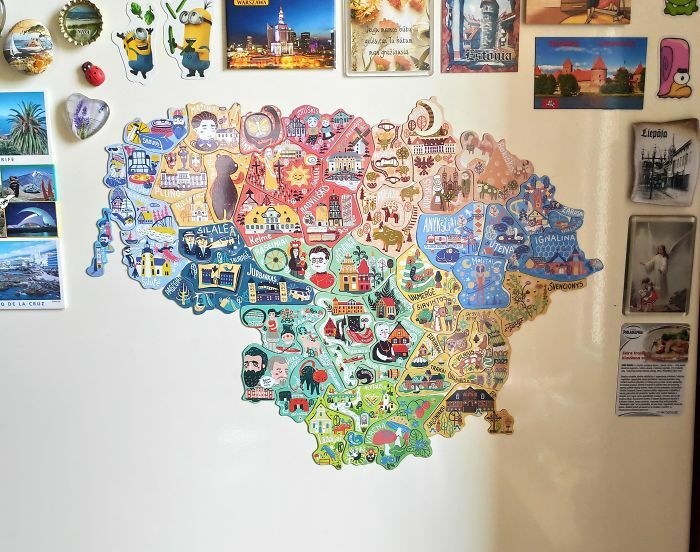

Image credits: StrawWordXbox
#2 Here Is A 1988 Map Of Berlin (Produced In The Ddr)
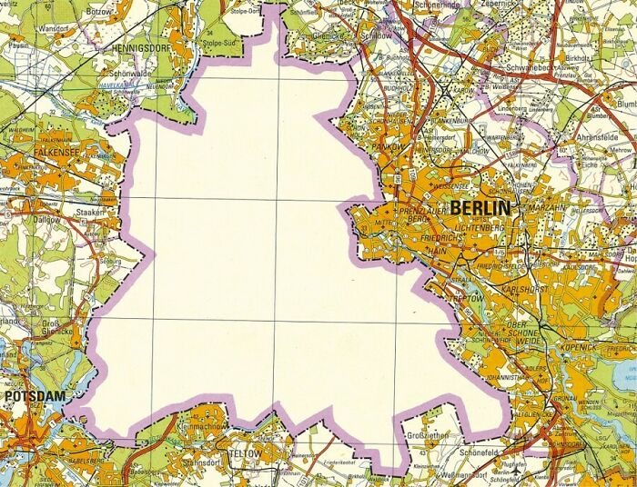
Image credits: BFNgaming
#3 Outline Of The World By Mapping All Lighthouses (Osm Data, Oc)
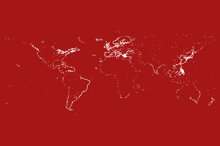
Image credits: bored_panda87
#4 Someone Here Posted A Map Of Earthquakes Since 1900(Top One) Now Watch It 1by1 To The Map Of Actual Tectonic Plates(Bottom One)
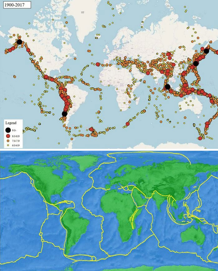
Image credits: Lntc26
#5 A Population Density Map Of Illinois
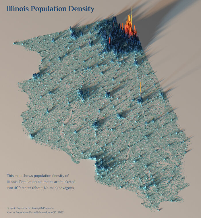
Image credits: Pecners
#6 Places That “Don’t Exist” According To Internet Memes (Many Based On The Original “Bielefeld Conspiracy”)
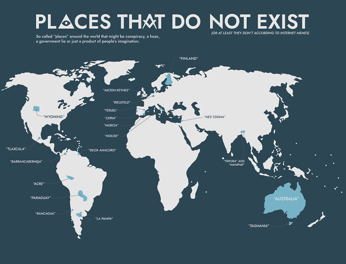
Image credits: DanArv1316
#7 Number Of Ukrainian Refugees Displaced In Europe In February 2023
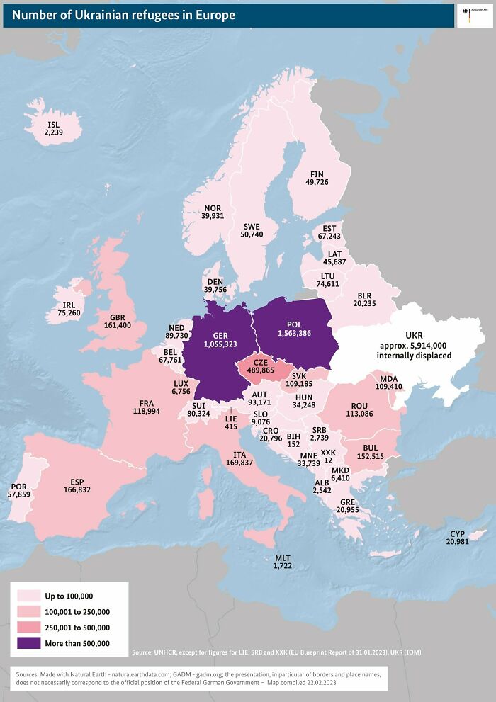
Image credits: Relocationstation1
#8 Countries Where It Is Illegal To Spank/Smack Children (700×700)
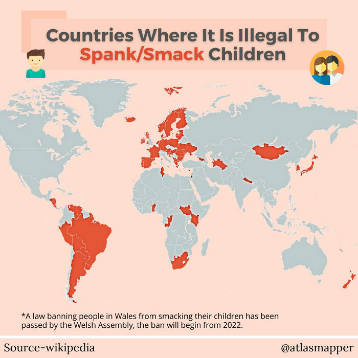
Image credits: john_doe_89
#9 Mediterranean Sea Fits Inside Australia – Should Be A Much Better Image Than Last One
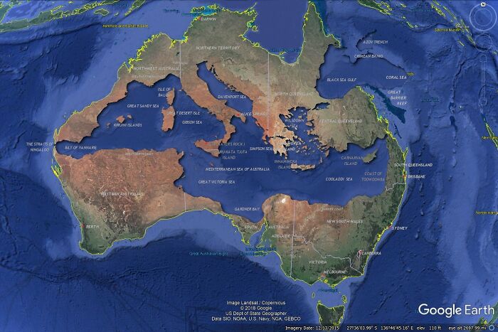
Image credits: SteelDeliverance
#10 The World In 250 Million Years
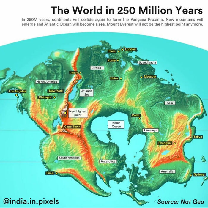
Image credits: Tacama
#11 Status Of Gay Marriage In Europe
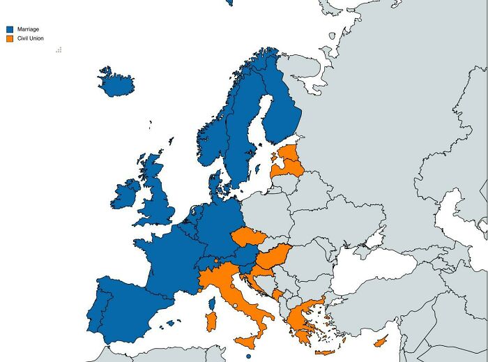
Image credits: Reasonable_Ninja5708
#12 Percentage Of Europeans Whose Wealth Is Under $10,000
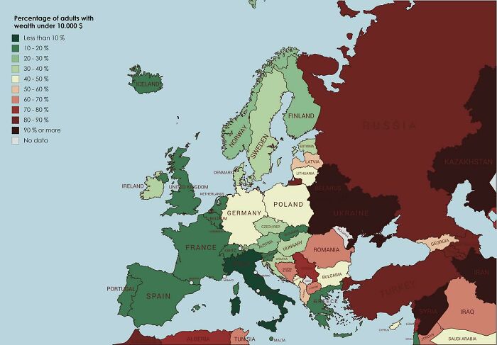
Image credits: Big-Way-9556
#13 Percentage Of Children Born Out Of A Registered Marriage
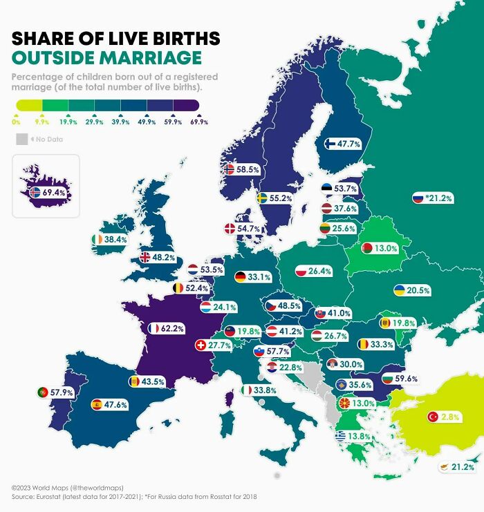
Image credits: theworldmaps
#14 What Year Is It Right Now?
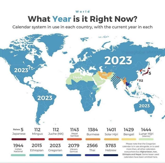
Image credits: ledim35
#15 The First World Map By Anaximander Of Miletus (610bc-546bc), Greece Mathematician And Geographist. Original Map Was Not Saved!
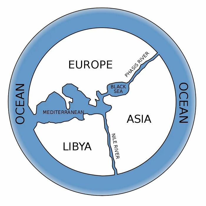
Image credits: Eli-Cohen
#16 Estimated Migration Of Early Homo Sapiens Out Of Africa To The Rest Of The World, In Thousands Of Years Ago (Kya)
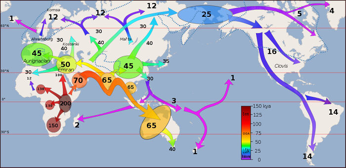
Image credits: CaptainJZH
#17 The Largest Towns In 1050 In Europe, North Africa And West Asia (Population Over 40 Thousand)
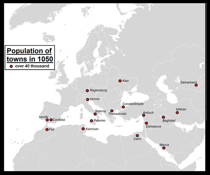
Image credits: Yellowapple1000
#18 1920 Australian Map Of Sheep
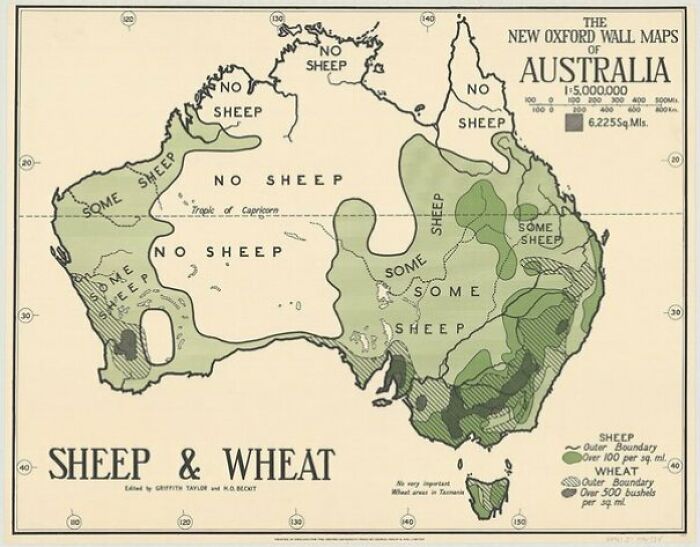
Image credits: Evilaars
#19 Relief Map Of San Marino
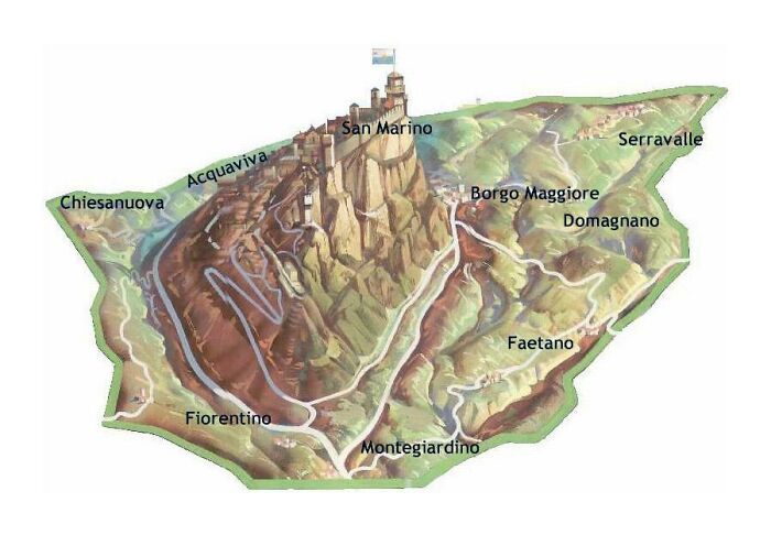
Image credits: Kl——–k
#20 Where Does The World’s Population Of 8 Billion Live?
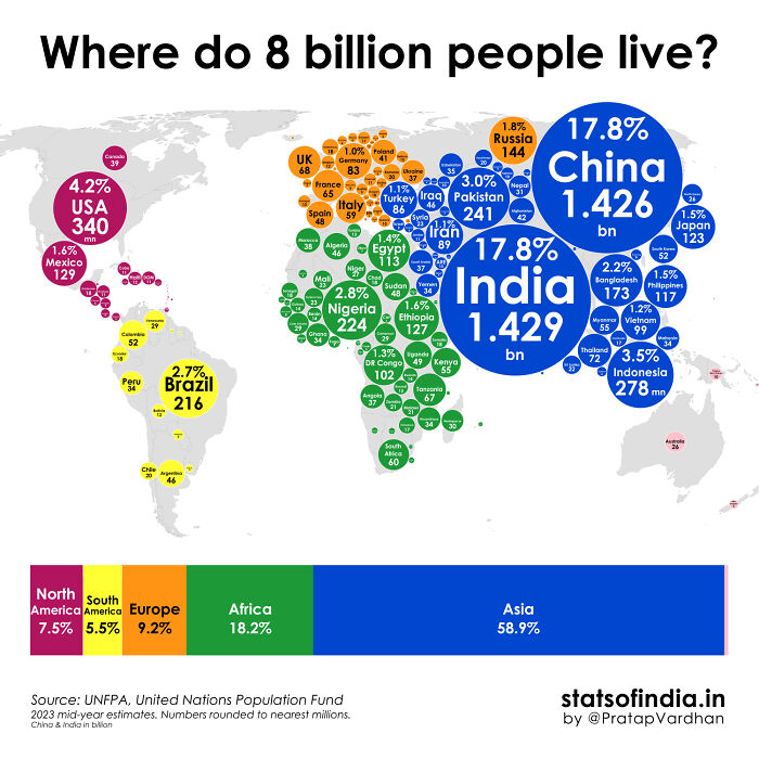
Image credits: pratapvardhan
#21 The Size Of Australia vs. Other Countries
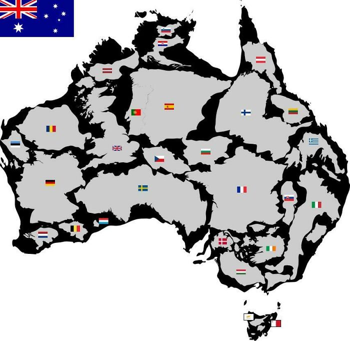
Image credits: charmanduuur
#22 The Swedish Empire At It’s Height
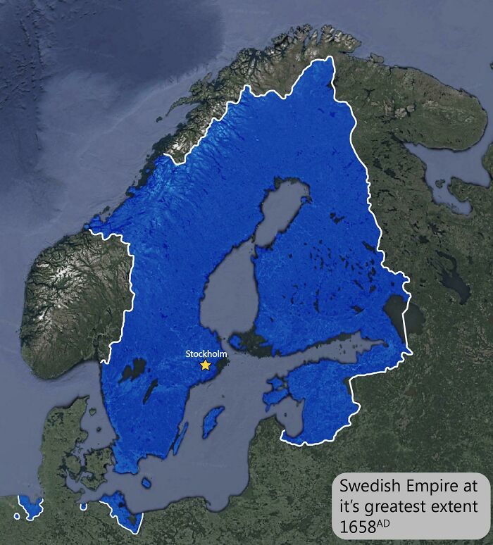
Image credits: MeatyEmperor
#23 Do You Agree With This Map Of Proposed Time Zones For Europe?
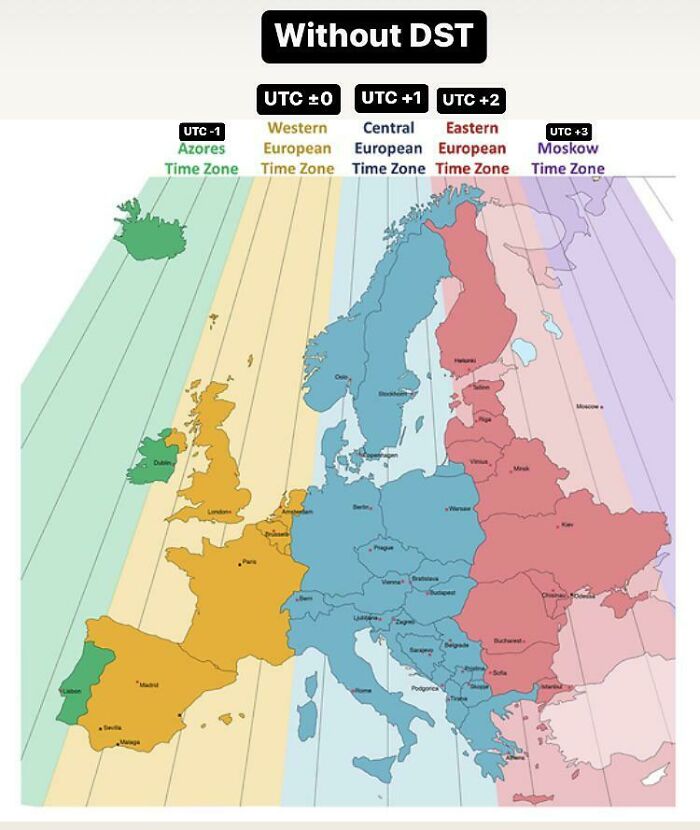
Image credits: HurryDifficult9115
#24 Russia’s New Border With Nato Now That Finland Is Finally In Nato!
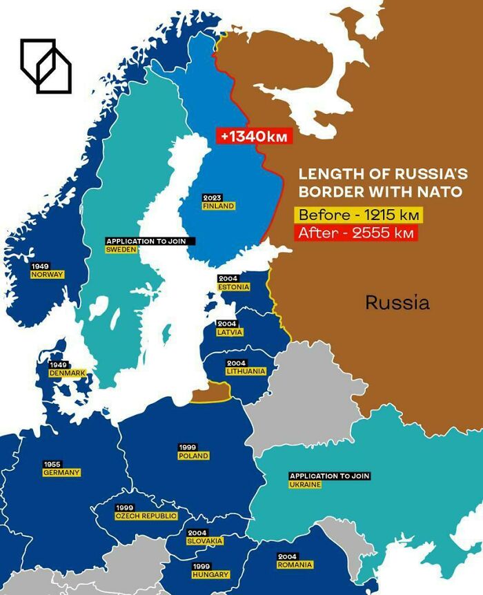
Image credits: AccurateSource2
#25 All Shootings vs. Shootings With Officer Involved In Chicago (2014-2022)
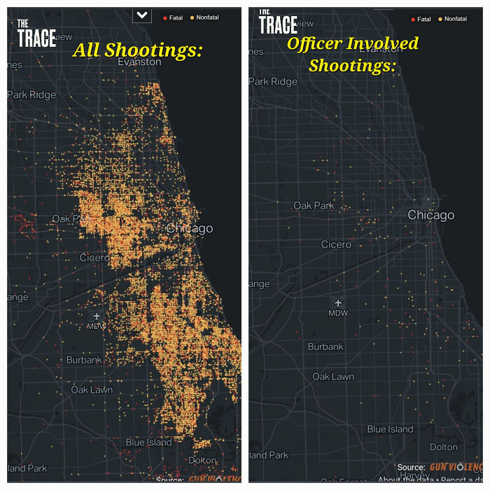
Image credits: flyingcatwithhorns
#26 Legality Of Prostitution
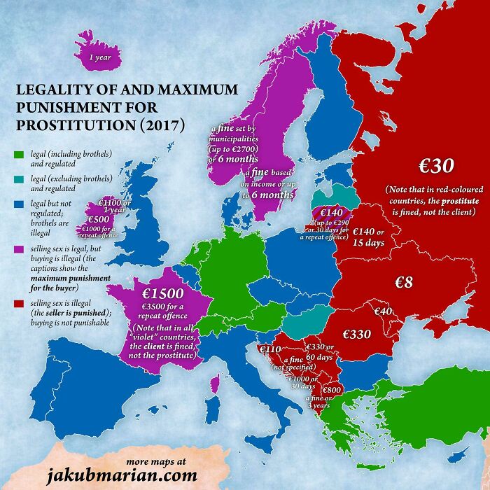
Image credits: Dijjkstra
#27 Can One Of You Euros Explain To Me What An Autonomous Region Is? Is It Like States And Provinces? Does It Make A Difference Between Federated And Unitary States? Why Is Spain So F’d Up?
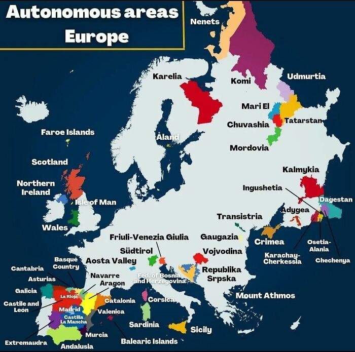
Image credits: BoBByMac74
#28 The Best And The Worst For Lgbtq+ Travelers
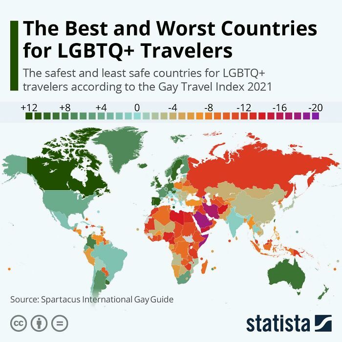
Image credits: EinHoer23
#29 Robbery Rates In European Countries
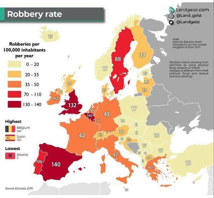
Image credits: Useless_or_inept
#30 When Were Southamerica’s Capitals Founded?
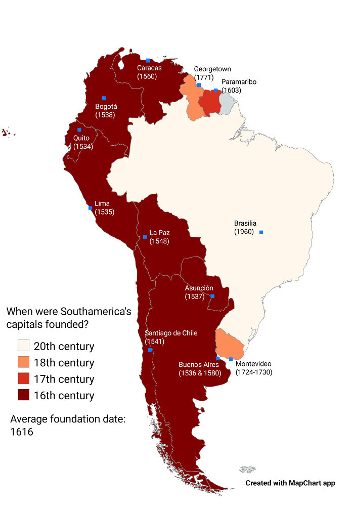
Image credits: alikander99
#31 Switching Europe Around: The Population Of The Most Populous Country Goes To The Country With The Biggest Area, The Population Of The 2nd Most Populous Country Goes To The One With The 2nd Biggest Area, And So On
Image credits: JoeFalchetto
#32 How Much Territory Russia And Ukraine Hold At One Year Of War
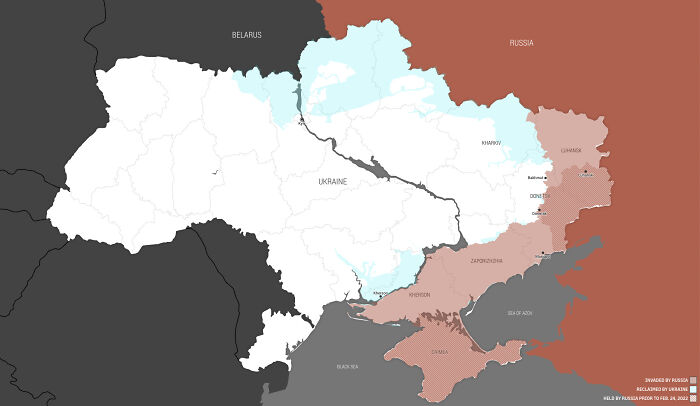
Image credits: HarpuasGhost
#33 Distribution Of The Roman Legions In Second Century Ce
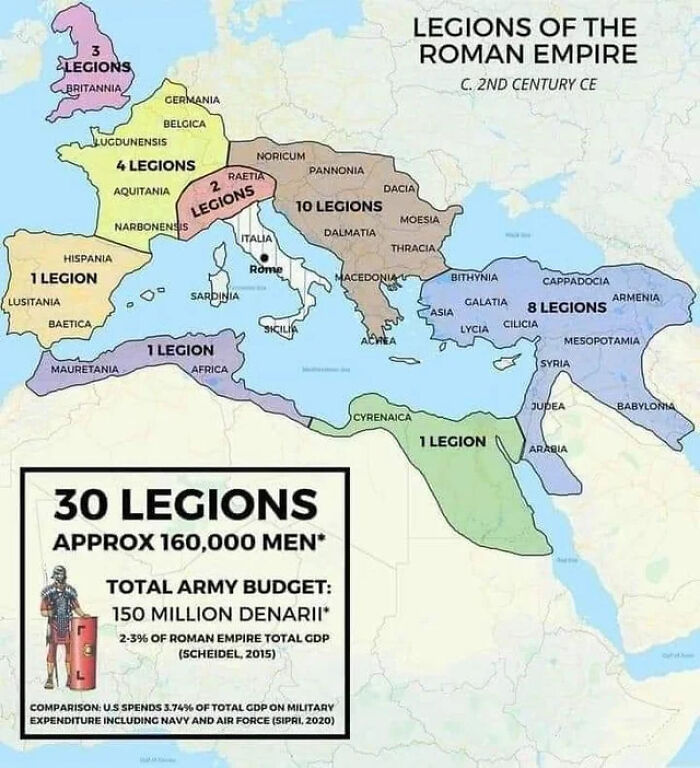
Image credits: brosiousIII
#34 Most Common Country Of Birth For Residents Of Foreign Origin, Excluding Mexico
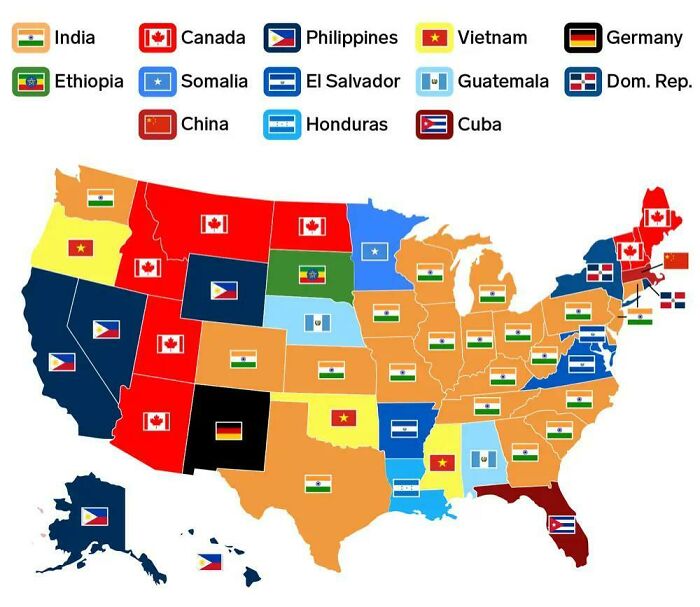
Image credits: red_ivory
#35 Public Transport Network Density
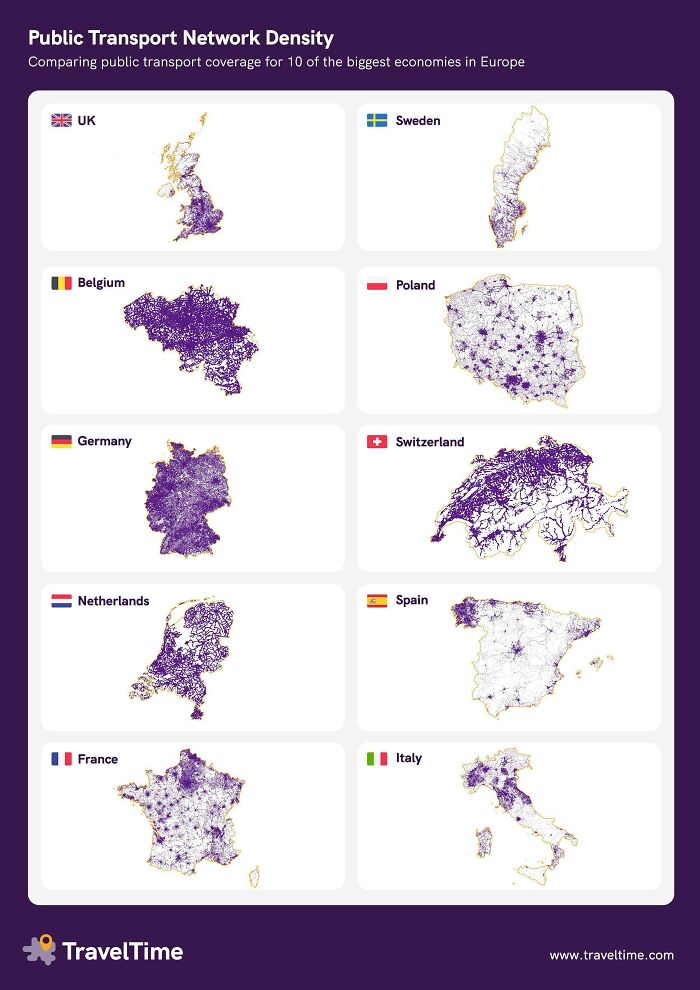
Image credits: YellowOnline
#36 Foreign Military Bases In Africa
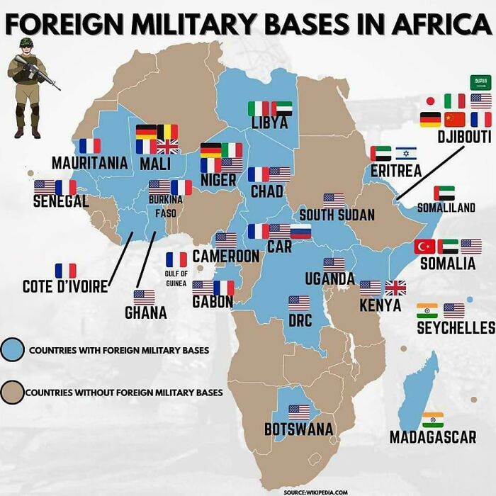
Image credits: lostproton
#37 The Atlantic Wall
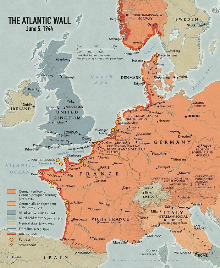
Image credits: cnut_thestraight
#38 America’s Car Reliance: Getting To Work Across 48 States Mapped
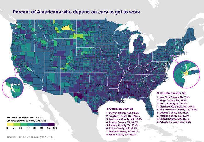
Image credits: feeeeshie
#39 England, Right To Roam Map
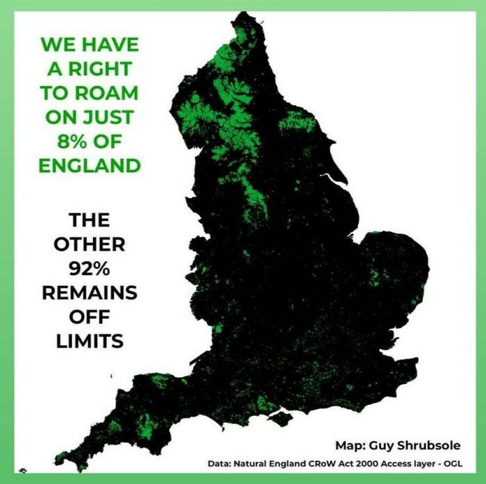
Image credits: B2RW
#40 Linguistic Map Of Spain
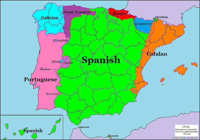
Image credits: No_Significance_8874
#41 The 2022 Edition Of The Global Peace Index
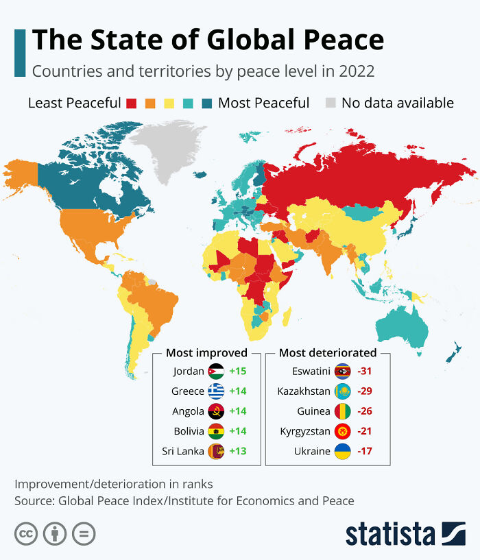
Image credits: 6_zeros
#42 Europeans Who Would Fight For Their Own Country
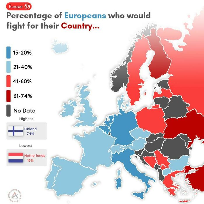
Image credits: CeceLovezz
#43 Kingdom Of Prussia In 1800 And Today’s Germany Borders
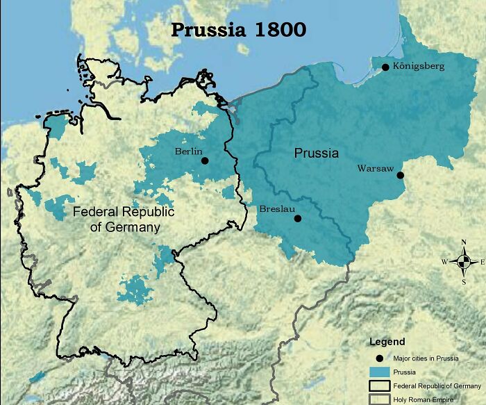

Image credits: Trinitytrenches
#44 How Big Brazil Actually Is!
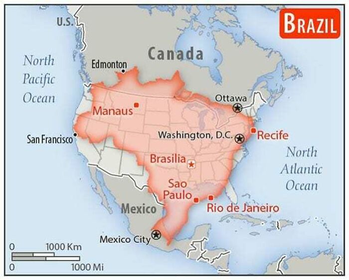

Image credits: AbhiExplains
#45 Turkey, Bordering 7 Different Countries With 7 Different Alphabets
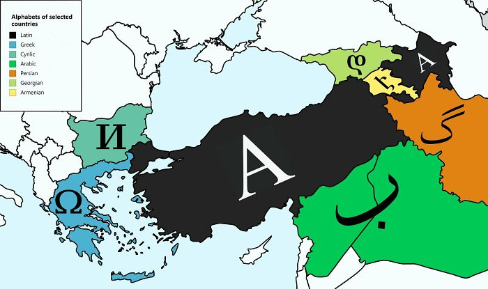

Image credits: Bladest0
#46 The United States As James K. Polk Wanted It [964 X 740]
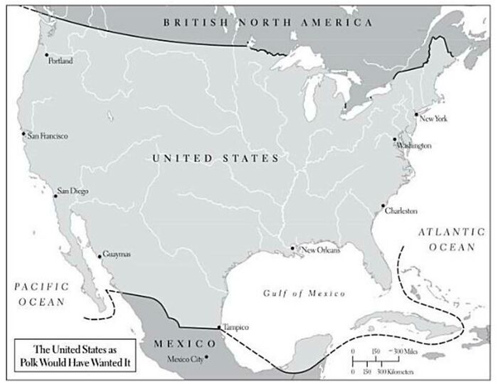

Image credits: i3w2iv4l11
#47 Fecal Bacteria Contamination In New York Waters, 1985 vs. 2020
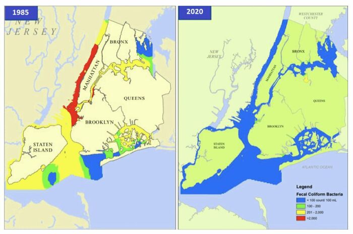

Image credits: Songs4Roland
#48 Israel’s Segregated Road System
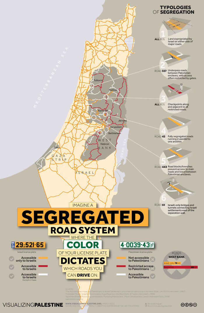

Image credits: Homesanto
#49 Biggest Source Of Electricity In The States And Provinces
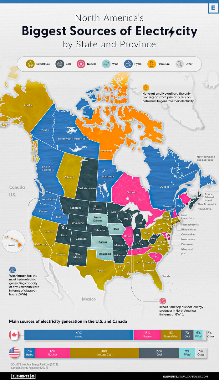

Image credits: Pirate_Secure
#50 Countries In Europe Where Escaping From Prison Isn’t A Crime
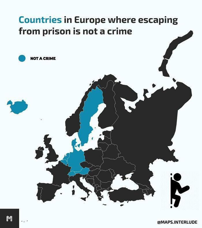

Image credits: ElPolloPayaso
#51 How Many Times More Likely Are Black Individuals To Be Imprisoned Compared To White Individuals In The Us?
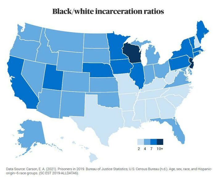

Image credits: flyingcatwithhorns
#52 Number Of Prisoners Per 100,000 People Across The World
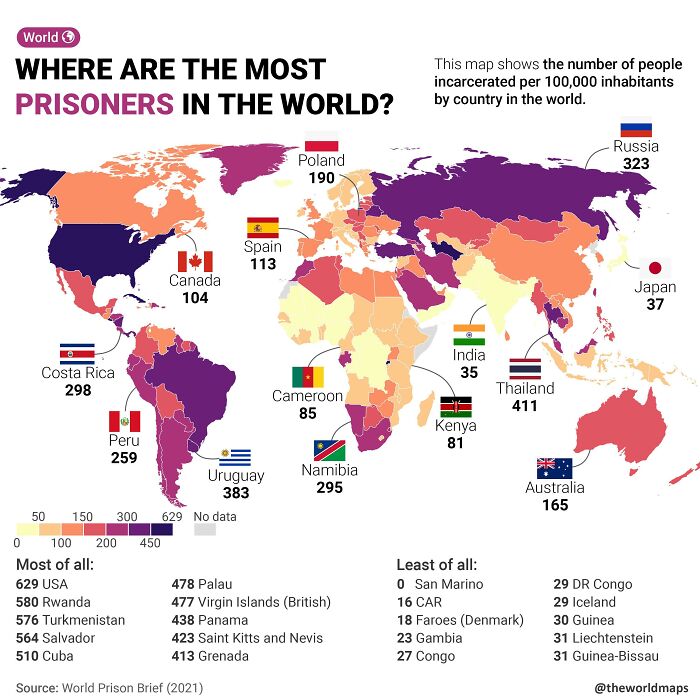

Image credits: flyingcatwithhorns
#53 Map Of The Percentage Of Population Able To Speak French In The Eu By Country
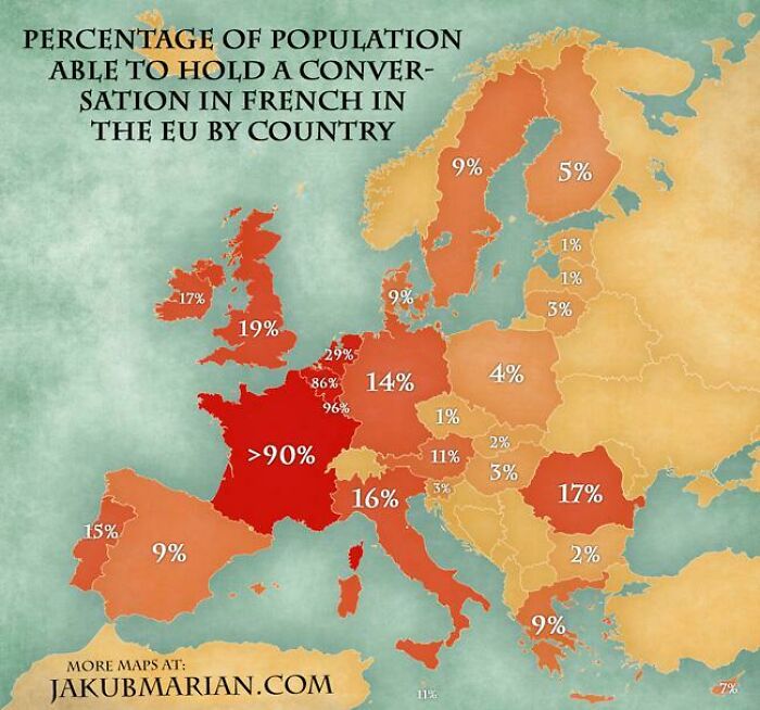

Image credits: MardukSyria
#54 The Euler Diagram-Map Of The British Isles./-
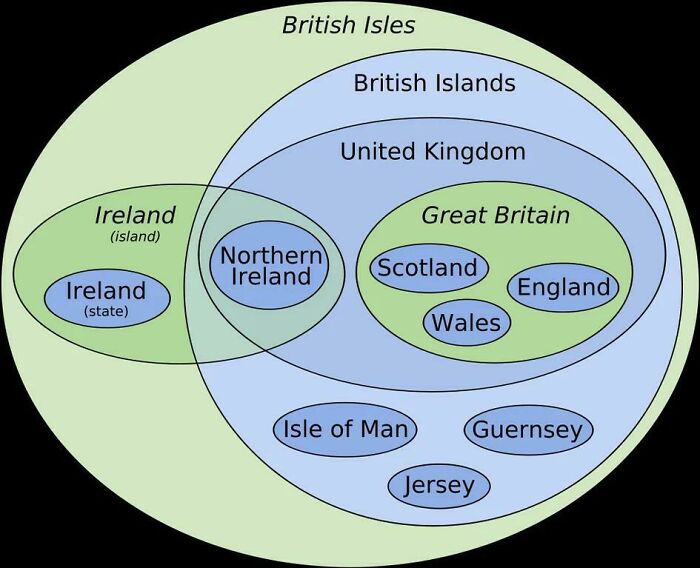

Image credits: MildCreator
#55 Cultural Regions Map Of The Contiguous 48 American States. V.5 ( Opinionated, Not Factual, Made With Communal Input)
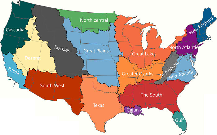

Image credits: Asleep_Bluebird18
#56 Equal Wealth Distribution Globally And Locally
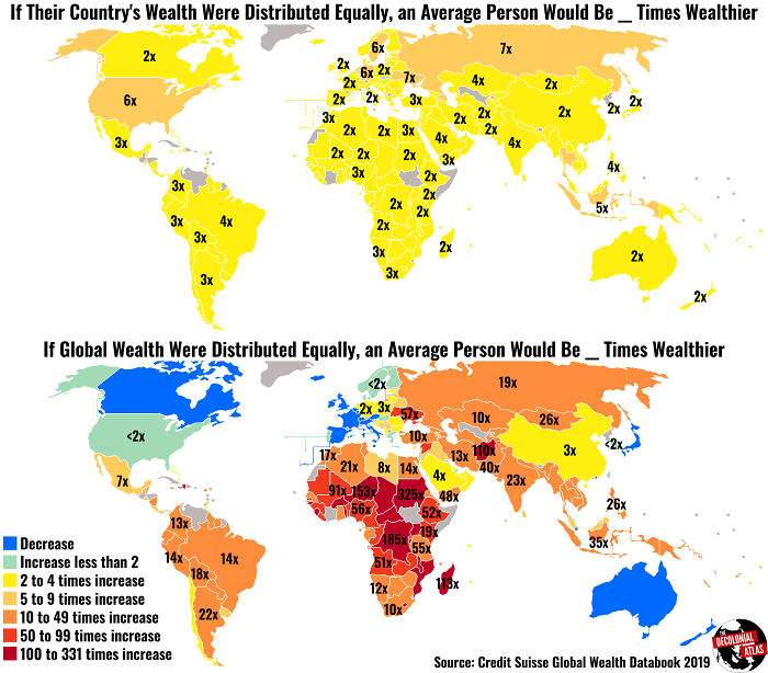

Image credits: summersunsun
#57 Us Travel Advisory Levels W/ Subdivisions
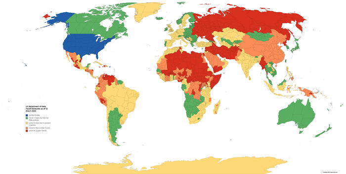

Image credits: mopscrub
#58 The 10 Countries With The Largest Populations That Didnt Make It Into The World Cup This Year
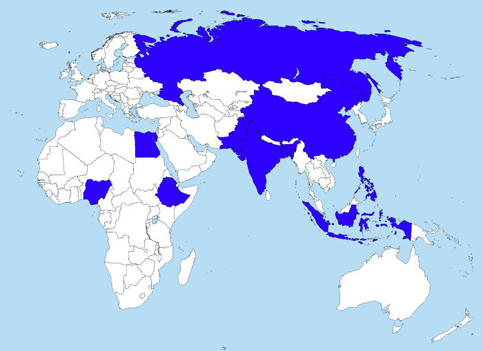

Image credits: Ok-Strategy-8582
#59 Africa’s Population Density
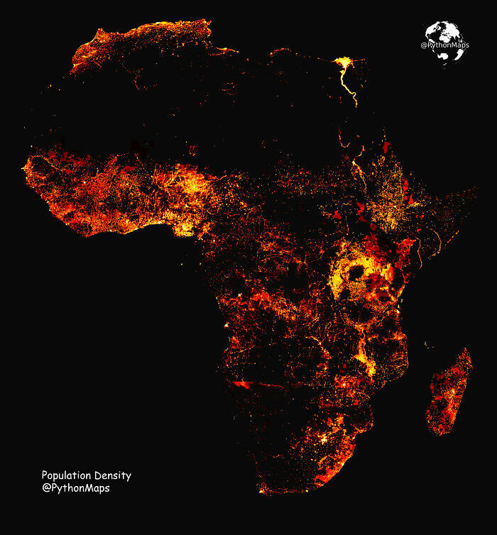

Image credits: AbhiExplains
#60 Ghana vs. The Ghana Empire
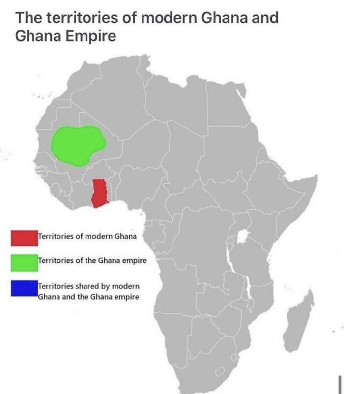

Image credits: proudly_disengaged
#61 Places Of Worship, North America
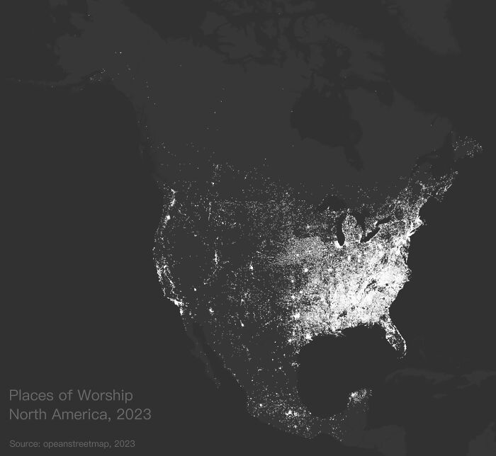

Image credits: feeeeshie
#62 San Andreas

Image credits: bozeminer
#63 Languages Spoken By European/North American Leaders
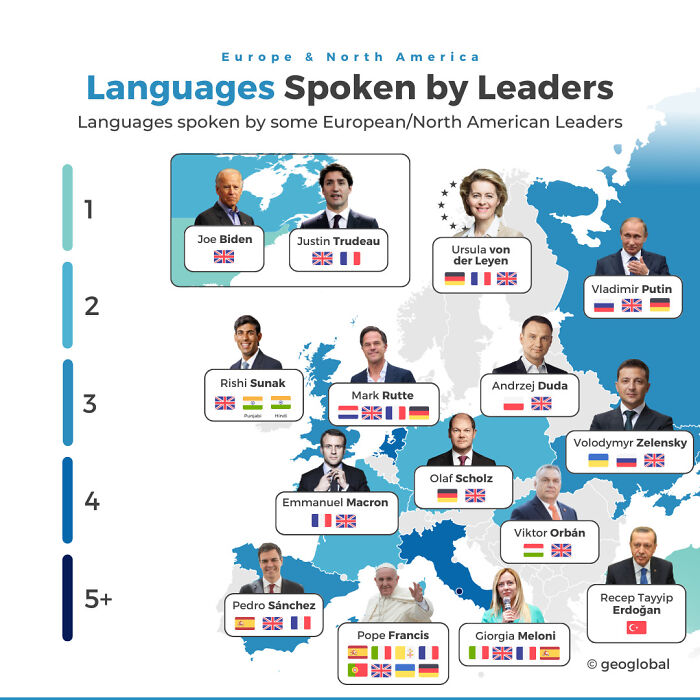
Image credits: geo_global
#64 Us States That Enforce Seatbelts
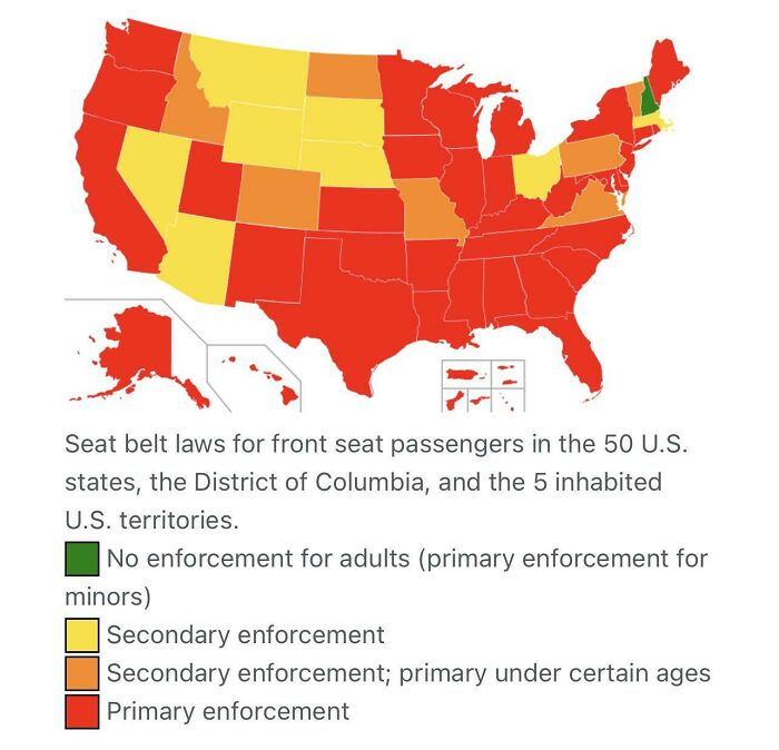

Image credits: drewb124
#65 Percentage Of Population Able To Hold A Conservation In German [607×650]
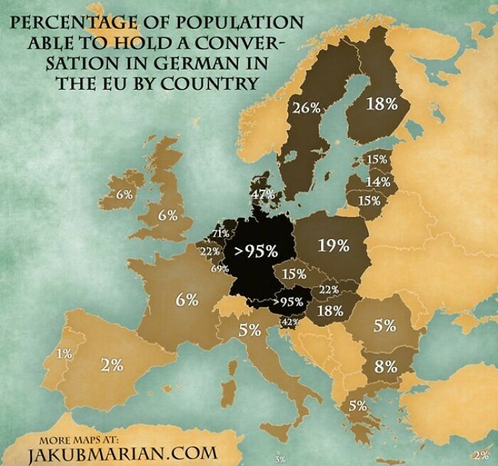
Image credits: Savin_N
#66 Countries By Self-Perceived Democracy
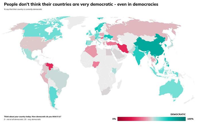

Image credits: real_LNSS
#67 Map Of Uncontacted Peoples Of The World

Image credits: anonymous_teen_guy
#68 Eu Countries Pushing To Label Nuclear Power As Green Energy
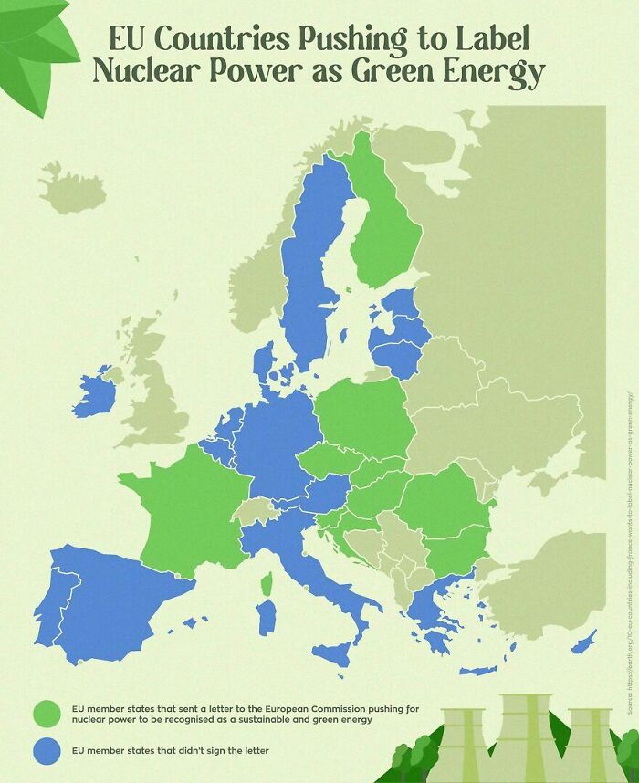

Image credits: ElPolloPayaso
#69 1984 Us Presidential Election
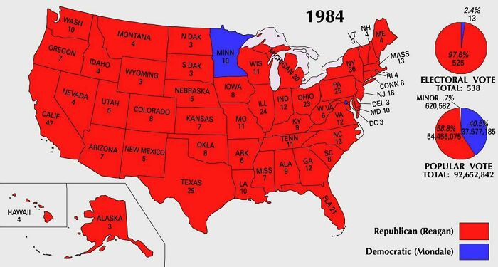

Image credits: Ladder310
#70 The U.S. Map Redrawn As 50 States With Equal Population
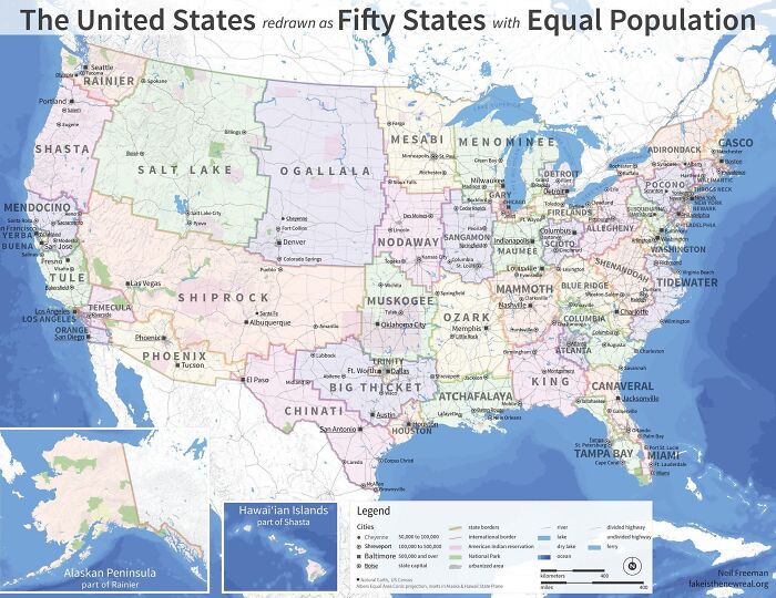

Image credits: afreshsplat
#71 Percentage Of Vegetarians In Every State Of India
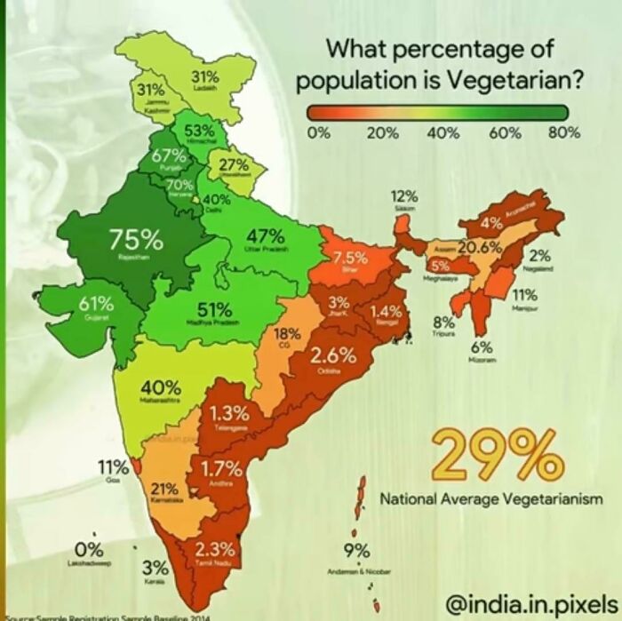

Image credits: khooni-darinda69
#72 In Red, The Territory Comprising The Initial Purchase Offer Given By Us Diplomat James Gadsden To Santa Anna In 1853

Image credits: afposthuman
#73 Italian And German Surnames In South America [oc]
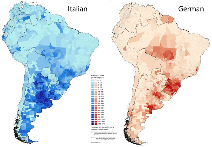

Image credits: scolbert08
#74 With Just Two 300 M Tracks, Vatican City Has The World’s Shortest Railway Network
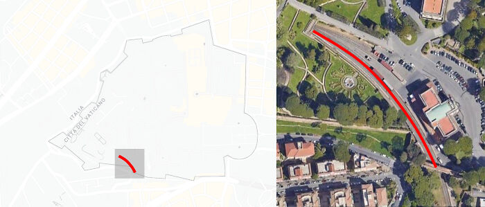

Image credits: Live_Wallaby9683
#75 Status Of Democracy In Europe According To The Eiu Democracy Index 2022
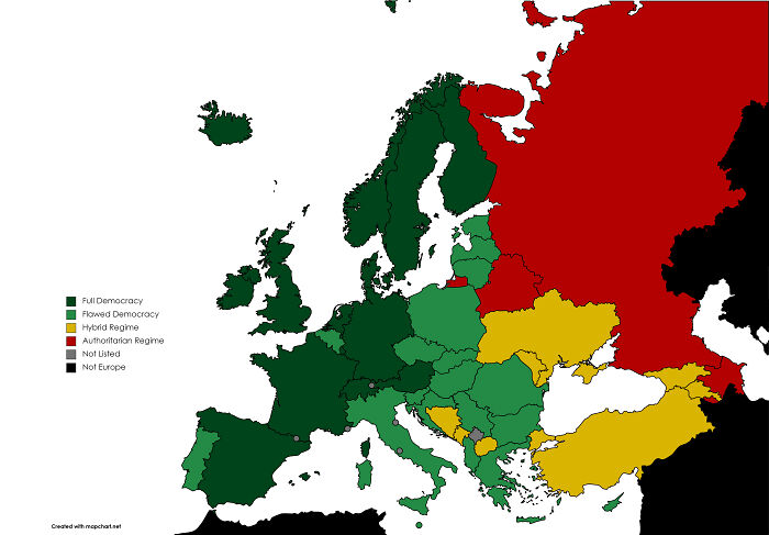

Image credits: Connor_The_Iguana
Source: boredpanda.com